
Track details
Distance
60.9km
Duration
19h 30min
Ascent
3644m
Descent
4010m
Starting altitude
722m
Arrival altitude
356m
Lowest point
188m
Highest point
1127m
Levigliani parking lot
Levigliani parking lot
Ticket counter Antro Corchia
It is recommended to show up at the ticket office at least 15 minutes before the shuttle departure from the village square
Parking can be done on site, or on the opposite side of the town (just entered on the right, ample parking – see specific notes)
Ticket counter Antro Corchia

It is recommended to show up at the ticket office at least 15 minutes before the shuttle departure from the village square
Parking can be done on site, or on the opposite side of the town (just entered on the right, ample parking – see specific notes)
+39 0584 778405
info@corchiapark.it
Barga parking lot
Barga parking lot
Cordati house
Panoramic place overlooking the Serchio valley and the Apuan Alps
guests in a charming 17th century building in the historic center of Barga
Three rooms with breakfast corner and private bathroom, two or more beds, an apartment complete with kitchen
The name is of the painter Bruno Cordati, whose exhibition you can visit during your stay, housed in the halls of the building.
Casa Cordati is a few meters from the two car parks in the historic center
Cordati house

Panoramic place overlooking the Serchio valley and the Apuan Alps
guests in a charming 17th century building in the historic center of Barga
Three rooms with breakfast corner and private bathroom, two or more beds, an apartment complete with kitchen
The name is of the painter Bruno Cordati, whose exhibition you can visit during your stay, housed in the halls of the building.
Casa Cordati is a few meters from the two car parks in the historic center
Panoramic point Passo Croce
Stunning panoramic point on the Apuan Riviera and at the same time on the heart of the central Apuan Alps from which the sharp reliefs of the Tambura, Sumbra, Fiocca mountains and in the distance Pizzod’Uccello, Pisanino, Cavallo and Sagro stand out
Panoramic point Passo Croce
Stunning panoramic point on the Apuan Riviera and at the same time on the heart of the central Apuan Alps from which the sharp reliefs of the Tambura, Sumbra, Fiocca mountains and in the distance Pizzod’Uccello, Pisanino, Cavallo and Sagro stand out
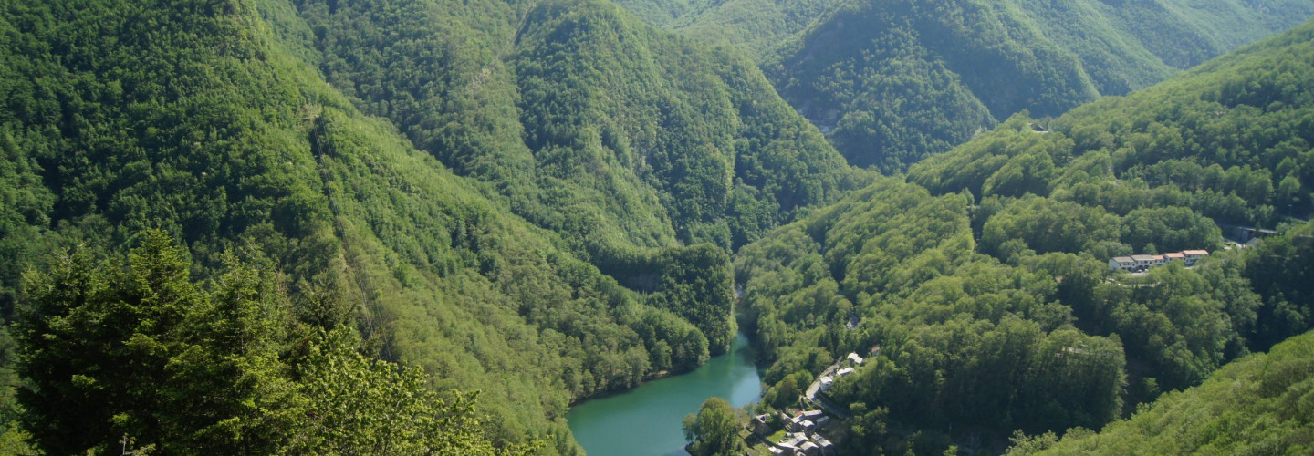
Isola Santa
Already on 1260 somebody wrote about a “Hospitale” in Isola Santa, that used to assist and give hospitality to those wayfarer who went through the Apuan Alps to reach the Versilia Coast or the Garfagnana in the opposite sense. Along this long and difficult journey Isola Santa was a fixed meeting point, was therefore probably fortified and had a watch tower (lost with centuries, but the street “via della Torre” still remains). Despite its strategic position, the little village was isolated and very difficult to reach due to the bad conditions of the communication routes, and its economy was very poor and simple. This isolation has been preserved for centuries, and ended only with the construction of the road and gallery of Cipollaio at the beginning of the 20th century. After this, in 1949 the construction of the dam changed radically the scene of this valley: the lake caused some troubles to the stability of the village, and the inhabitants of Isola Santa slowly abandoned their houses. The typical houses that we offer to our guests are part of the project of global restoration that has the intent of bringing this little medieval village to life again, to combine its antique charm with the wonders of the natural environment.
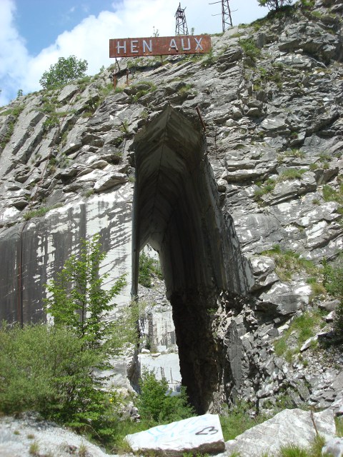
Henraux quarries Tre Fiumi
The Tre Fiumi area is a rugged and wild basin at about 750 meters above sea level affected by quarries and ravaneti, in particular by the spectacular quarry, now abandoned, called “le Tagliate”, which still carries the Henraux sign at the entrance. The type of quarry is a rare example of a mining site with a rock curtain crossed by a large helical wire cut. In the area some of the service buildings of the marble excavation activity are still preserved. The Tre Fiumi area was home to the block loading and marble measurement terminal of the Alta Versilia marble railway, active from 1923 to 1947 and “loader hillock” of many of the quarries of the Anonima S.Henraux company in the area of Arni. The town owes its name to the confluence of three river branches of the Canale del Freddone and Tùrrite Secca.
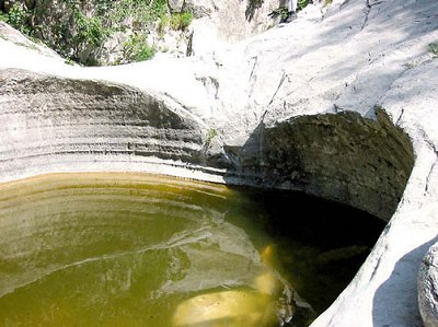
The giants' pots
Access to the ditch Anguillaja: parked the vehicle on the edge of the provincial road of Val d’Arni (687 m above sea level), which leads to Castelnuovo Garfagnana, you walk on foot along an old cart track, which opens on the left and descends towards the Dry Tùrrite. After 250 m you reach the watercourse which, as a rule, is completely dry, since it is characterized by a subalveous circulation. After having traveled the arid bottom in a northerly direction, while the river shaft draws a recessed meander, you immediately meet the confluence from the left of the Anguillaja ditch (650 m above sea level), largely modified by the old cuts and the abandoned residues of a Marble quarry. The mining activity also canceled the first ‘potholes’ that existed in the lower part of the same ditch, artificially shaping its bottom and its side walls.
The Anguillaja is an intermittent watercourse on a temporary basis, on the occasion of heavy rains, which presents some remarkable ‘potholes’, described for the first time by Masini (1929). At that time, the last 300 m of the ditch descending from M. Sumbra, showed 13 large cauldron cavities. Their number then decreased due to the destruction produced years ago by the disused quarry of its lower section. The surviving ‘potholes’, now protected by the Regional Park, are easily observable by continuing the short itinerary along the Anguillaja. The ascent of the ditch is relatively easy at the beginning and, the first morphological jump, is overcome thanks to a small iron staircase. This leads to the spectacular succession of three ‘potholes’ of significant proportions, completely carved out of marble (see photo on the side).
Further on, the route requires practice in the use of the double rope and in climbing adherence on rock.
Morphogenesis: the ‘pots of the giants’ often owe their origin to the abrasive action of rotating pebbles. The development requires several coincident conditions, including the swirling movement of the river current and a coherent and homogeneous rocky substrate, such as the marble of M. Sumbra.
The ‘mufflers’ of Anguillaja and Fatonero also seem to refer to this model, as the signs of mechanical erosion on the inner edges of the large cauldron cavity shown on the side would demonstrate.
However, some Authors have hypothesized a genesis of these ‘potholes’ in a forced regime, through subglacial tunnels that were to be located in the southern slope of Sumbra and Fiocca, in correspondence with glaciers or perennial snowfields formed during the last ice age.
For others, chemical dissolution (surface karst) may have initially prepared the cavities, on which the hydrodynamic action then had a prevalent or exclusive reason (Federici et alii, 1981).
A look at the Fatonero ditch, the Fiocca and the Sumbra
From the provincial road of Val d’Arni, 700 m further upstream from the Anguillaja, the Fatonero ditch is easily identifiable, of which the last 400-500 m of stretch can be observed, descending from M. Fiocca. The ‘potholes’ have been numbered decreasing as the ditch goes up: in all they are 21 and the same size as the twin ditch. They too are carved out of marble.
On the way up the M. Fiocca, from the Fatonero ditch, we find, in succession, Marbles, Selciferous Limestones, Diaspri, Selciferous Limestones at Entrochi, Sericitic Schists and Pseudomacigno, with different repetitions due to minor folds. It should also be noted the presence of three tiny klippe of cavernous limestone. M. Sumbra, on the other hand, consists mainly of Marbles and Selciferous Limestones. The southern slopes of these two hills are characterized above all by karst and glacial modeling. The rounded furrows of the south wall of the Sumbra are linked to cryonal processes, due to perennial snowfields or small ephemeral masses of ice.
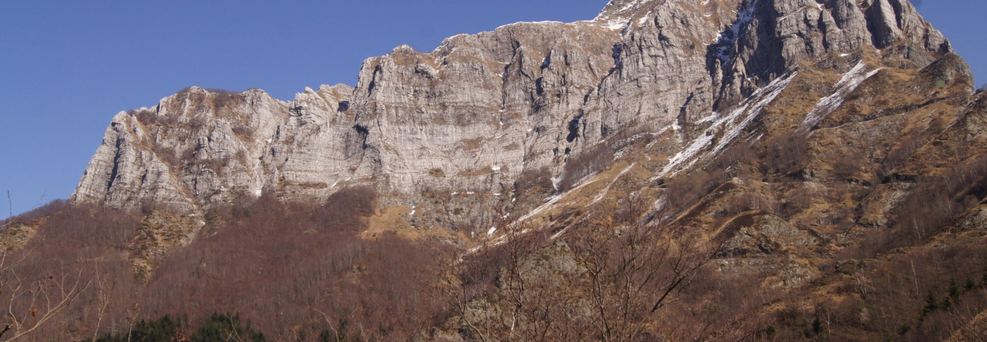
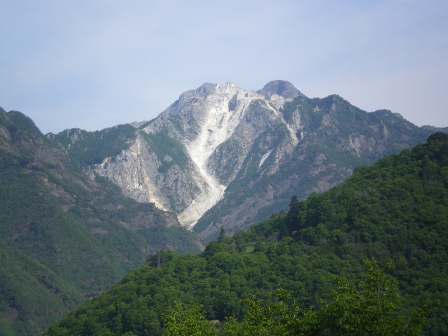
Monte Altissimo- Cervaiole quarries
The south-western side of the mountain is characterized by an imposing sub-vertical wall of over 700 m in height which makes it majestic and easily identifiable from the whole coast of Versilia, to which it is rather close. Its north-eastern side is much less craggy and is locally covered with beech woods.
The mountain is renowned for the fine marbles quarried mainly in the Le Cervaiole locality owned by the company Henraux srl. The sequence of Monte Altissimo marbles consists of a basal part made up of white and gray marble alternating in regular benches with a reduced thickness of 0, 8-1.20 meters, followed by an intermediate part made up of well layered benches of white and statuary marbles with limited gray marbles. In the highest part of the sequence, marble takes on a more massive appearance and the benches are no longer easily defined. The statuary marble, typical of the intermediate part of the “sequence”, is always well identified by a level of muscovite 0.5-2 cm thick, which seems to constitute a sedimentary “marker”, present on both the southern and northern sides of the structure.
Along the slopes of the mountain you can visit the trenches of the “Gothic Line”, built by the Germans in the Second World War and also ancient “lizze”, ie roads to slide the large marble blocks downstream.